GCOM-C
What is GCOM-C / SGLI?
- GCOM-C is a JAXA satellite. SGLI is a single sensor on the GCOM-C satellite.
- wikipedia
- SGLI data are free.
- It is low spatial resolution (250 m ~ 1 km) but high temporal resolution (every 2~3 day).
- The start of observation is Janunary 1st, 2018.
- observation schedule 観測計画 https://shikisai.jaxa.jp/obsplan/obsplan_j.html
- 34日回帰
JAXA website for GCOM-C data manual, tools, etc.
- https://gportal.jaxa.jp/gpr/information/tool?lang=ja#GCOM-C ... この下のほうに日本語文書がある。
- SIN投影からlatlonへの投影変換は, "気候変動観測衛星「しきさい」(GCOM-C)データ利用ハンドブック(2020.12.22更新)"のP53あたり。以前の版にはミスがあったのが修正されている。
- 随時改訂されるので最新版を見るべし。直リンクは古い文書に飛ぶ可能性があるので危険。
- https://shikisai.jaxa.jp/faq/faq0025_j.html ... 日本語文書。
- https://gportal.jaxa.jp/gpr/information/tool?lang=ja
- SGLIレベル1プロダクトフォーマット説明書
- SGLI高次プロダクトフォーマット説明書
- RSR high resolution / low resolution
- SGLIセンサ特性ガイド https://suzaku.eorc.jaxa.jp/GCOM_C/resources/files/SGLI_Characterization_Guide_20110404.pdf
How to get GCOM-C/SGLI data
- Go to G-Portal website of JAXA.
- Register yourself in G-Portal
- Access G-Portal, search, and get the data!
access with ftp command
FTP is easy and useful. Here is an example:
$ sftp -oPort=2051 AP12345@ftp.gportal.jaxa.jp
password: ******
sftp> ls standard/GCOM-C/GCOM-C.SGLI/L2.LAND.LAI_/1/2018/11/10/
sftp> get standard/GCOM-C/GCOM-C.SGLI/L2.LAND.LAI_/1/2018/11/10/GC1SG1_20181110D01D_T1413_L2SG_LAI_Q_1000.h5
access with your browser
Try like this (The browser will ask you your username and password of G-Portal.):
- sftp://ftp.gportal.jaxa.jp:2051/standard/GCOM-C/
- sftp://ftp.gportal.jaxa.jp:2051/standard/GCOM-C/GCOM-C.SGLI/L2.LAND.RV02.Statistics/3/2022/
- 2051 is the port number of G-Portal sFTP site.
Download with curl command
シェルでダウンロード: wgetはsftpに対応していないので無理(だろう)。そこでcurlを使う。
$ curl -O -u (username):(password) sftp://ftp.gportal.jaxa.jp:2051/standard/GCOM-C/GCOM-C.SGLI/L2.LAND.RV02.Statistics/3/2022/01/GC1SG1_20220109D08D_T0529_L2SG_RV02Q_3000.h5
- -O ... use the original filename for download destination. ダウンロード元のファイル名をそのまま使う。
- -u ... give your username and password. ユーザー名:パスワードを指定。
How to look inside a GCOM-C/SGLI data file
(in case of Ubuntu Linux)
$ h5dump -n GC1SG1_20181215D01D_D0000_3MSG_LST_F_1000.h5
$ h5dump -d /Image_data/LST GC1SG1_20181215D01D_D0000_3MSG_LST_F_1000.h5
$ qgis GC1SG1_20181215D01D_D0000_3MSG_LST_F_1000.h5
reprojection and file format conversion tool (for Linux shell)
Download and extract:
$ wget https://gportal.jaxa.jp/gpr/assets/mng_upload/GCOM-C/SGLI_geo_map_linux.zip
$ unar SGLI_geo_map_linux.zip
$ chmod +x SGLI_geo_map_linux.exe
Use it:
$ ./SGLI_geo_map_linux.exe GC1SG1_20220125D08D_T0529_L2SG_RV02Q_3000.h5 -d /Image_data/Rs_VN02_AVE -r NN
Then you will get GeoTiff file.
- -d option gives a "HDF5 dataset" name, which you can find and choose by h5dump -n command.
- -r NN option means "nearest neighbor". If you skip this, bi-linear method is used, and it makes a gap between tiles.
Open it with QGIS!
$ qgis GC1SG1_20220125D08D_T0529_L2SG_RV02Q_3000_Rs_VN02_AVE.tif
Mosaic:
$ ./SGLI_geo_map_linux.exe GC1SG1_20220125D08D_T0529_L2SG_RV02Q_3000.h5 -d /Image_data/Rs_VN02_AVE -r NN
$ ./SGLI_geo_map_linux.exe GC1SG1_20220125D08D_T0429_L2SG_RV02Q_3000.h5 -d /Image_data/Rs_VN02_AVE -r NN
$ gdal_merge.py GC1SG1_20220125D08D_T0529_L2SG_RV02Q_3000_Rs_VN02_AVE.tif GC1SG1_20220125D08D_T0429_L2SG_RV02Q_3000_Rs_VN02_AVE.tif -n 65535 -a_nodata 65535 -ul_lr 122 46 149 24
Filename rule
(P12~15 of https://gportal.jaxa.jp/gpr/assets/mng_upload/GCOM-C/SGLI_Higher_Level_Product_Format_Description_jp.pdf)
example of level3 product: GC1SG1_20181215D01D_D0000_3MSG_LST_F_1000.h5
GC1: (satellite) GCOMC-1
SG1: (sensor) SGLI1
20181215: (observation timing) 2018 December 15
D: (orbit; descending or ascending) descending
01D: (temporal coverage) 1-day
D0000: (spatial coverage) global? (perhaps)
3M: (level and "map or binned") level3 map
S: "standard"
G: "global" ... L: "near real time local", N: "near real time global"
LST_: (parameter) land surface temperature
F: (spatial resolution) 1/24 deg spatial resolution ... "K": 1 km, "H": 0.5 km, "Q": 0.25 km
1: algorithm version
000: parameter version
h5: (file format) HDF5 format
example of level2 product: GC1SG1_20181110D01D_T1413_L2SG_LAI_Q_1000.h5
GC1: GCOMC-1
SG1: SGLI1
20181110: 2018 November 10
D: Descending
01D: (temporal coverage) 1-day
T1413: tile number 1413. vv=14, hh=13
L2: level2
S: "Standard"
G: "Global"
LAI: LAI product
Q: Resolution 250m
1: Algorithm version
000: parameter version
h5: HDF5 format
orbit 軌道
D (descending)
A (ascending)
Temporal Coverage (Statistics Period) 観測時期
01D: 1-Day
08D: 8-Day
01M: 1-Month
Spatial coverage 観測範囲
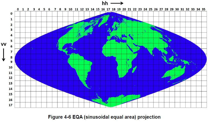
scene
half-path
tile ... sinusoidal projection tile. one tile is about 1100 x 1100 km
   0529: central Japan
   0528: west and north Japan
   0428: north Japan and Hokkaido
global ... latlon projection (equal rectangular projection; plate caree)
Mapping 地図化
You can see the definition and characteristics of mapping method here (Chapter4 of https://gportal.jaxa.jp/gpr/assets/mng_upload/GCOM-C/GCOM-C_SHIKISAI_Data_Users_Handbook_en.pdf) .
- 0529: 関東~中部~近畿~四国~九州南部
- 0528: 東北~北陸~九州北部
- 0428: 北海道~東北北部
from "GCOM-C "SHIKISAI" Data Users Handbook, First Edition", December 2018, JAXA
ID names of products (parameters)
SGC-180024 気候変動観測衛星「しきさい」(GCOM-C)データ利用ハンドブックより
- AAEL aerosol angstrom index over land (UV)
- AAEO aerosol angstrom index over ocean
- AAEP aerosol angstrom index over land (polarization)
- AGB_ above ground biomass and roughness index
- AOTL aerosol optical thickness on land (UV)
- AOTO aerosol optical thickness on ocean
- AOTP aerosol optical thickness on land (polarization)
- ARNP aerosol non-polarimetric
- ARPL aerosol polarimetric
- ASSA aerosol single scattering albedo on land
- CDOM colored dissolved organic matter (Level 3, ocean)
- CERW cloud (water) particle size
- CFR1~9 cloud amount (Level3, atmosphere)
- CFRA~M cloud amount (Level3, atmosphere)
- CHLA chlorophyll A concentration (Level 3, ocean)
- CLFG cloud flag
- CLPR cloud parameters
- CLTH cloud top height
- CLTT cloud top temperature
- COTI cloud (ice) optical thickness
- COTW cloud (water) optical thickness
- EVI_
- FPAR
- GEOx geolocation of x (V: VNR-NP, I: IRSm P: VNR-PL)
- IWPR (water quality product)
- L380 normalized water leaving radiance (Level 3)
- L412 normalized water leaving radiance (Level 3)
- L443 normalized water leaving radiance (Level 3)
- L490 normalized water leaving radiance (Level 3)
- L530 normalized water leaving radiance (Level 3)
- L565 normalized water leaving radiance (Level 3)
- L670 normalized water leaving radiance (Level 3)
- LAI_ leaf area index (& FPAR for Level 2)
- LCLR radiance at top of atmosphere after cloud removal
- LST_ land surface temperature
- LTOA radiance at top of atmosphere
- NDVI
- NDVI = DigitalNumber *0.0001 - 1.0
- reference: P70 https://gportal.jaxa.jp/gpr/assets/mng_upload/GCOM-C/SGLI_Higher_Level_Product_Format_Description_jp.pdf
- NWLR normalized water leaving radiance
- OKID Okhotsk sea ice distribution
- PAR_ photosynthetically active radiation (Level 3, ocean)
- RVxx VNR-NP band xx reflectance
- RSxx IRS-SWIR band xx reflectance
- RTxx IRS-TIR band xx Brightness temperature (unit: K)
- RPxx VNR-PL band xx reflectance
- RNxx VNR-NP band xx reflectance matched to VNR-PL
- RLAx relative azimuth angle (?) of x (V: VNR-NP, I: IRSm P: VNR-PL)
- RSRF land surface reflectance
- SDI_ shadow index
- SGSL snow grain size
- SICE snow & sea ice distribution
- SIPR snow surface parameters
- SIST snow surface temperature
- SLZx solar zenith angle (?) of x (V: VNR-NP, I: IRSm P: VNR-PL)
- SNZx sensor zenith angle (?) of x (V: VNR-NP, I: IRSm P: VNR-PL)
- SST_ sea surface temperature
- T670 atmospheric correction parameter (Level 3, ocean)
- T865 atmospheric correction parameter (Level 3, ocean)
- TSM_ suspended material (Level 3, ocean)
- VGI_ vegetation index
- VRI_ vegetation roughness index
How to get the physical quantities from DN numbers
if we want to use physical quantities like reflectance, we need to convert DN value stored in the file by using "slope" and "offset". The following equation converts DN value to physical quantities (L). If you are interested in more details of product descriptions, it's recommended to read this document ( https://gportal.jaxa.jp/gpr/assets/mng_upload/GCOM-C/SGLI_Higher_Level_Product_Format_Description_en.pdf ).
L=(DN)*(Slope)+(Offset)
Slopes and offsets for level-2 products are shown below.
- Slope (Reflectance of RVxx and RSxx): 0.0001
- Offset (Reflectance of RVxx and RSxx): 0.0
- Slope (Brightness temperature of RTxx): 0.01
- Offset (Brightness temperature of RTxx): 0.0
DN value "65535" is used for the indication of error value.
Spatial resolution
K: 1km
H: 500m
Q: 250m
F: 1/24deg.
C: 1/12deg.
Keyword(s):
References: