HRLULC-Japan 2024 with Species-Level Orchard Categories
(Released in February 2026 / 2024JPN_v26.02_orchard)
連絡先|Contact info.
伊藤 駿(いとう しゅん; Shun ITO)
所属(当時):筑波大学理工情報生命学術院 (Graduate School of Science and Technology, University of Tsukuba)
shun.ito1128[at]gmail.com
※送信時は [at] を @ に変更してください。When send e-mail, please chage [at] to @.
本プロダクトについて | About this product: 2024JPN_v26.02_orchard
本プロダクトは2024年の日本全域(Sentinel-2衛星での観測頻度が不十分な一部の離島を除く)の状況を反映した日本域高解像度土地利用土地被覆図バージョン26.02 (2024JPN_v26.02_orchard: 果樹園を詳細化) です。 カテゴリ,使用データ,精度は以下をご覧ください。また,zipファイルの中にREADMEファイルが格納されていますので,そちらも併せてお読みください。今後はさらなるカテゴリの追加や高精度化,入力データの改良等に取り組んでまいります。
| 対象期間 | 2024年 |
|---|---|
| 座標系 | 等緯度経度座標系 (WGS84) |
| 格納単位 | 緯度経度1度単位のグリッドタイル, 12,000ピクセル × 12,000ライン |
| メッシュサイズ | (1/12,000) 度 × (1/12,000) 度 (およそ10 m × 10 m: 10 m解像度に相当) |
| ディレクトリ・ファイル 命名規約例 |
2024JPN_v26.02_orchard └── LC_N36E140.tif (上記の場合、2026年2月にリリースされた2024年の日本域を対象に作成されたプロダクトのうち、 北緯36から37度、東経140から141度の範囲を指します。) |
| 格納形式 | GeoTIFF形式 |
| ファイル数 | ファイル数: 118 タイル
|
| 付記・免責事項 | このプロダクトは, JAXA HRLULCのスピンオフ研究として, JAXA EORCおよびRESTECのご協力を頂きながら, 筑波大学として作成したものです。研究段階のものであり, 学術目的以外でのご利用は想定しておりません。従って, ご利用にあたっては, それに伴って生じうるいかなる損害についても, 筑波大学および作成者は責任を負わないことをあらかじめご承知ください。 |
Interactive Map Preview
You can switch background maps and toggle LULC visibility using the layer panel in the top-right corner.
Legend:
Download link
This product is available from following link. When use this, please cite the following article.
[Eng. ver.] Ito, S., Mizuno, Y., Shimada, S., Hirayama, S., Tadono, T., Imamura, K., Hirade, N., Ohgushi, F., Satake, R. and Nasahara, K.N. Improvement of JAXA's High-Resolution Land Use and Land Cover Map of Japan with Species-Level Orchard Categories, Journal of The Remote Sensing Society of Japan, 2026 [accepted]
2024JPN_v26.02_orchard: 27 categories
Download (.zip): 705.8 MBカテゴリ定義|Category Definitions
Figure 1: Definition and number of reference data for each category. Note that the original category “Cropland” in JAXA HRLULC-Japan has been renamed to “Herbaceous cropland” in this study, as woody crops (orchards) are segregated and classified as independent categories.
ワークフロー|Classification Workflow
Figure 2: Workflow of the hierarchical classification in this study. Note that the 1st and 2nd level classifications are executed sequentially as independent processes, each encompassing classification, ensemble learning, and post-processing. The 2nd level classification is performed exclusively for the pixels classified as "Deciduous orchard" in the finalized 1st level LULC map. Both levels utilize the same input data and the same classifier SACLASS 2.5.
使用したデータ|Input Data
Figure 3: List of input data.
分類アルゴリズム|Classification Algorithm (SACLASS2.5)
Figure 4: Processing flow of SACLASS2.5 developed by JAXA.
精度評価|Accuracy Assessment
教師情報とは独立の検証情報を用いて, 第1階層分類(20カテゴリ),第2階層分類(8カテゴリ)それぞれの混同行列による精度検証を実施しました。以下に精度検証結果を示します。なお,精度検証については, 検証点がランダムサンプリングでない理由等で誤差が生じることをご留意ください。
- 1st step classification: 93.2 ± 0.5 %
- 2nd step classification: 85.2 ± 3.5 %
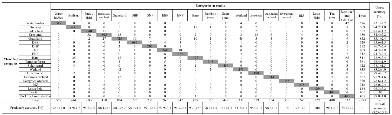
Figure 5a: Confusion matrix for the 1st step classification (Major categories). Error bars represent the 95 % confidence interval.
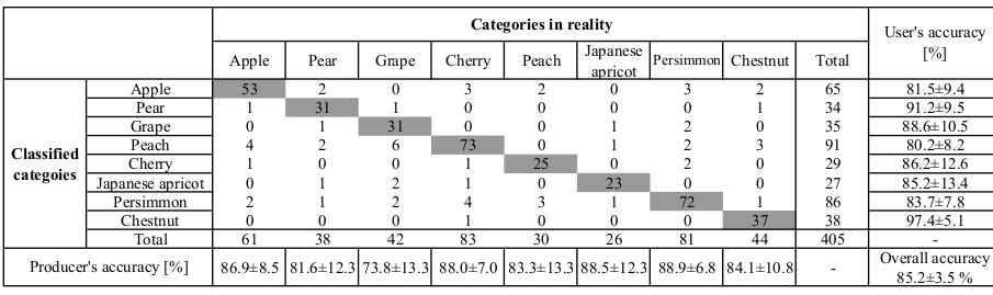
Figure 5b: Confusion matrix for the 2nd step classification focusing on detailed orchard categories. Error bars represent the 95 % confidence interval.
分類結果の概観|Regional Classification Results
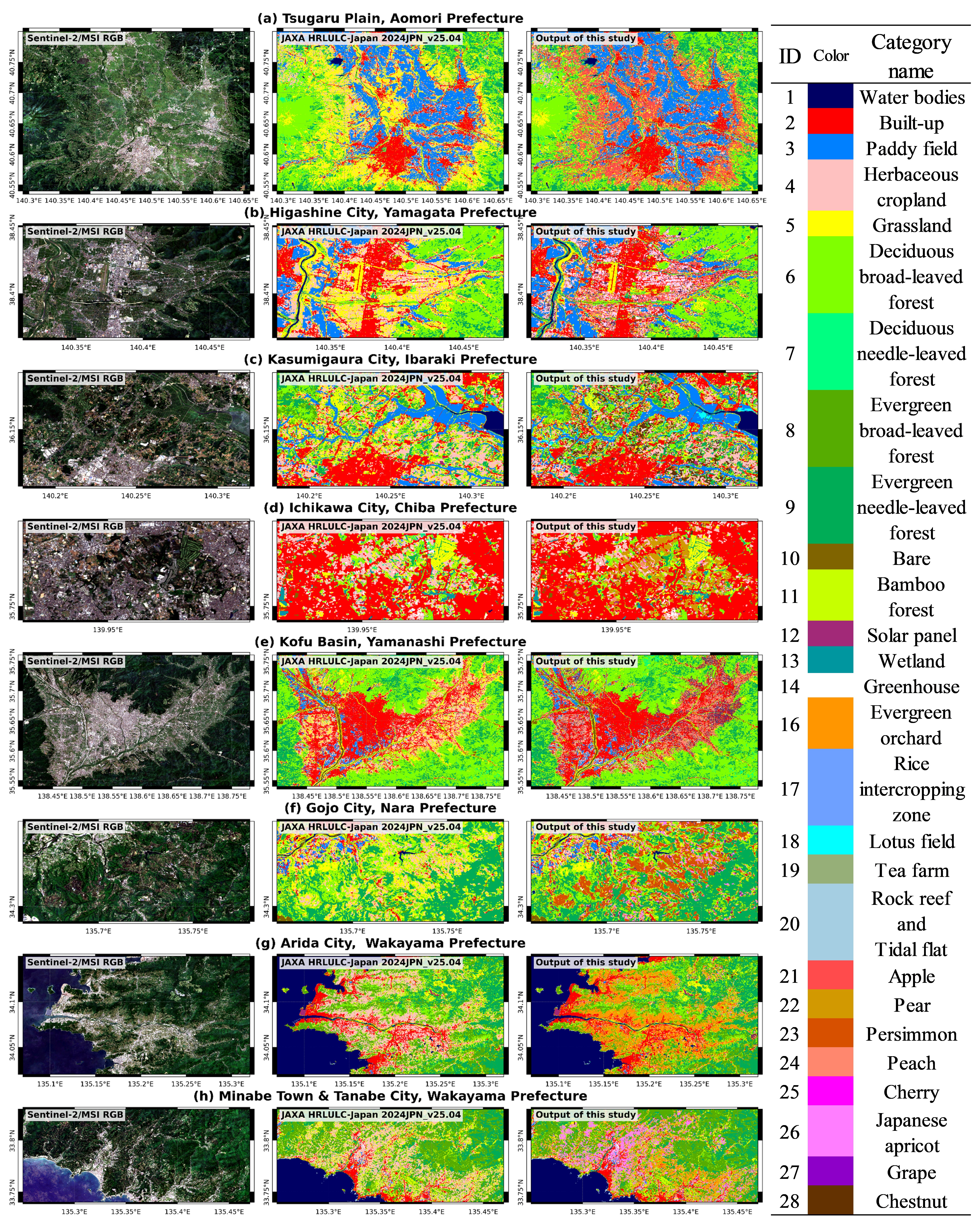
Figure 6: Comparison of JAXA HRLULC-Japan 2024JPN_v25.04 and the output of this study in major fruit-growing regions, along with true color Sentinel-2/MSI image (median composite of July–August 2024). JAXA HRLULC-Japan 2024JPN_v25.04 consists of 15 categories (Category ID: 1 – 14, 20), while the output of this study consists of 27 categories (Category ID: 1 – 14, 16– 28).