High-Resolution Land-Use and Land-Cover Map
around Western Indonesia 2023
(Released in March 2026 / 2023IDN_v26.03)
Project Status: This dataset is part of our ongoing high-resolution mapping project. Technical notes and regional analysis results are being updated periodically on this page.
付記・免責事項: このプロダクトは, JAXA HRLULCのスピンオフ研究として, JAXA EORCおよびRESTECのご協力を頂きながら, 筑波大学として作成したものです。研究段階のものであり, 学術目的以外でのご利用は想定しておりません。従って, ご利用にあたっては, それ>に伴って生じうるいかなる損害についても, 筑波大学および作成者は責任を負わないことをあらかじめご承知ください。
付記・免責事項: このプロダクトは, JAXA HRLULCのスピンオフ研究として, JAXA EORCおよびRESTECのご協力を頂きながら, 筑波大学として作成したものです。研究段階のものであり, 学術目的以外でのご利用は想定しておりません。従って, ご利用にあたっては, それ>に伴って生じうるいかなる損害についても, 筑波大学および作成者は責任を負わないことをあらかじめご承知ください。
Interactive Map Preview
You can switch background maps and toggle LULC visibility using the layer panel in the top-right corner. Default: OpenStreetMap.
Legend:
Download link
2023IDN_v26.03: 17 categories
Download (.zip)Category Definitions
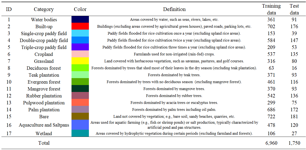
Figure 1: Classification scheme and ID definitions for 2023IDN_v26.03, capturing diverse tropical landscapes including complex plantation types.
Classification Algorithm
This product utilizes a hierarchical classification approach. The classification algorythm is "SACLASS2.5" developed by JAXA, which combines Convolutional Neural Networks (CNN) and Multi-Layer Perceptrons (MLP).
Input Data
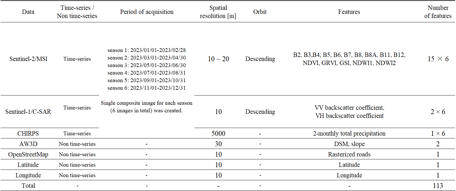
Figure 2: List of input data.
Accuracy Assessment: Confusion Matrix
The classification accuracy was evaluated using independent ground truth and high-resolution reference samples.
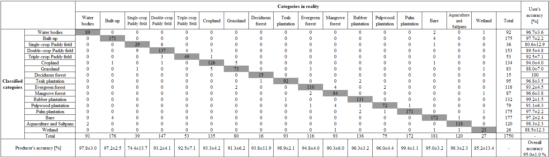
Figure 3: Confusion matrix for the 2023IDN_v26.03 dataset.